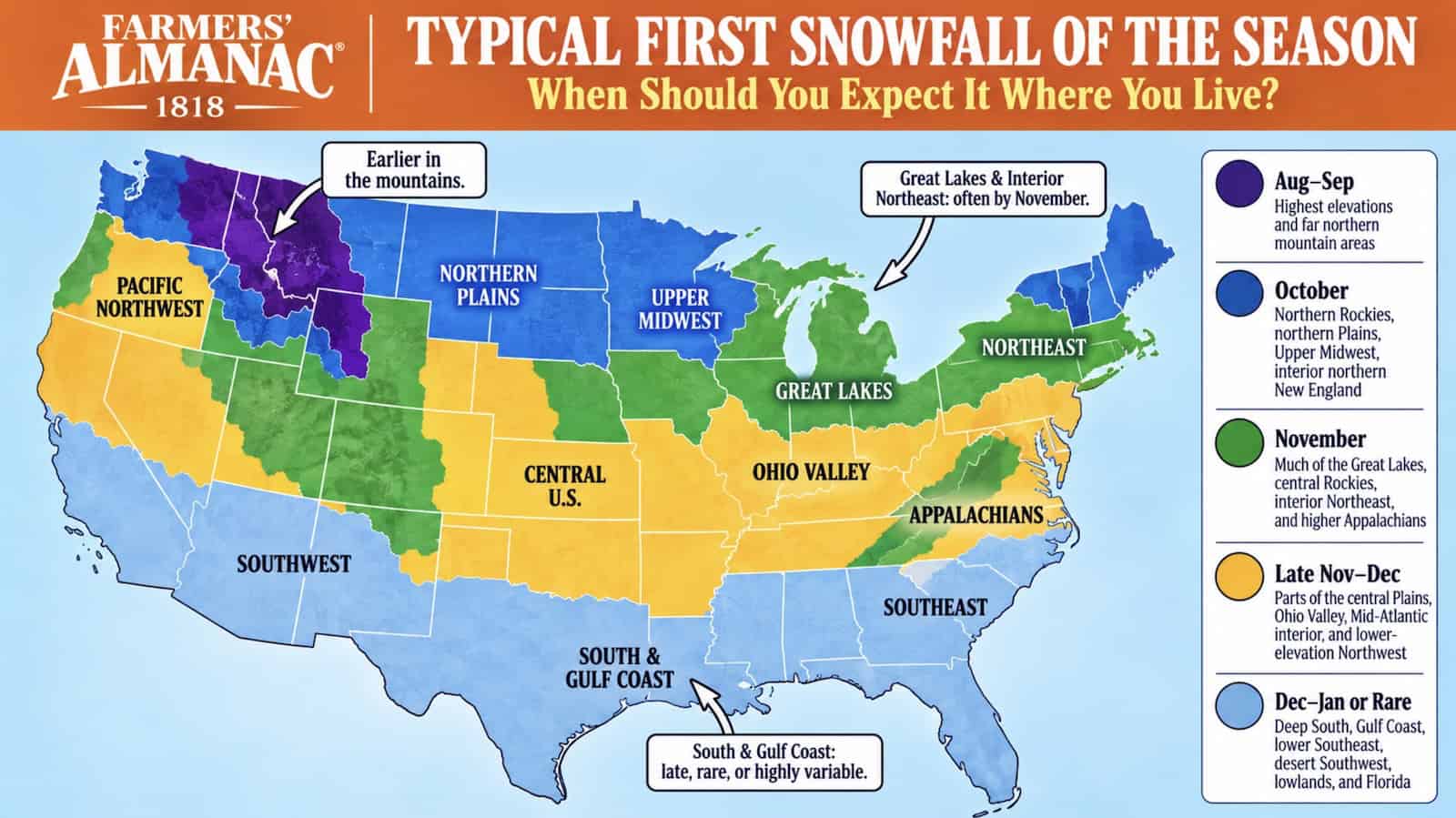
The Farmers' Almanac provides a comprehensive climatological guide for the 2026 season, detailing when the first snowfall typically hits various regions of the United States, from the high Rockies to the Gulf Coast.
- Highest elevations see snow as early as August or September.
- The Northern Plains and Upper Midwest typically experience snow in October or early November.
- The Deep South and Gulf Coast may wait until January or see no snow at all.
For millions of Americans, the arrival of the first snowfall marks the definitive transition into winter. According to the Farmers' Almanac, this transition is not uniform; it is a staggered process dictated by elevation, latitude, and proximity to large bodies of water. While mountain peaks may be capped in white by September, the southern reaches of the country remain temperate well into December.
Regional Timeline of the First Snow
The climatological data divides the Lower 48 states into five distinct periods. The process begins in the highest elevations of the northern Rockies during August and September. By October, the "Northern Snow Belt" comes alive, with states like Montana, Wyoming, and North Dakota seeing their first measurable accumulations. For instance, Denver averages its first measurable snow around October 18, though extremes have seen it as early as September 3.
| Timeframe | Most Likely Areas |
|---|---|
| Aug–Sep | Highest elevations & far northern mountains |
| October | Northern Rockies, Northern Plains, Upper Midwest |
| November | Great Lakes, Interior Northeast, High Appalachians |
| Late Nov–Dec | Central Plains, Ohio Valley, Mid-Atlantic |
| Dec–Jan or Rare | Deep South, Gulf Coast, Florida, Desert Southwest |
Why This Matters
BozokMedia analysis shows that understanding these patterns is critical for municipal planning and emergency preparedness. The "Lake Effect" snow in the Great Lakes region, caused by cold air passing over warm lake water, can create sudden, blinding blizzards that differ significantly from the gradual accumulations seen in the interior plains, necessitating different infrastructure responses.
"The distinction between a trace of snow and measurable snowfall is the difference between a scenic morning and a logistical challenge for city planners."
Defining the 'First Snow'
Meteorologists emphasize that not all snow is created equal. They categorize the event into three milestones: First Flakes (snow that melts on contact), First Measurable Snowfall (at least 0.1 inch of accumulation), and First Significant Snowfall (one inch or more). These milestones can be weeks apart; in cities like Chicago, the first flakes may appear in October, while the first shovel-worthy snow doesn't arrive until much later.
Frequently Asked Questions
Q1: Is this a forecast for a specific storm?
No, this is a climatological guide based on historical averages, not a short-term weather forecast.
Q2: Why does snow arrive so quickly in the Great Lakes region?
Warm lake waters in autumn provide heat and moisture to cold Canadian air masses, triggering intense localized snowfall.

