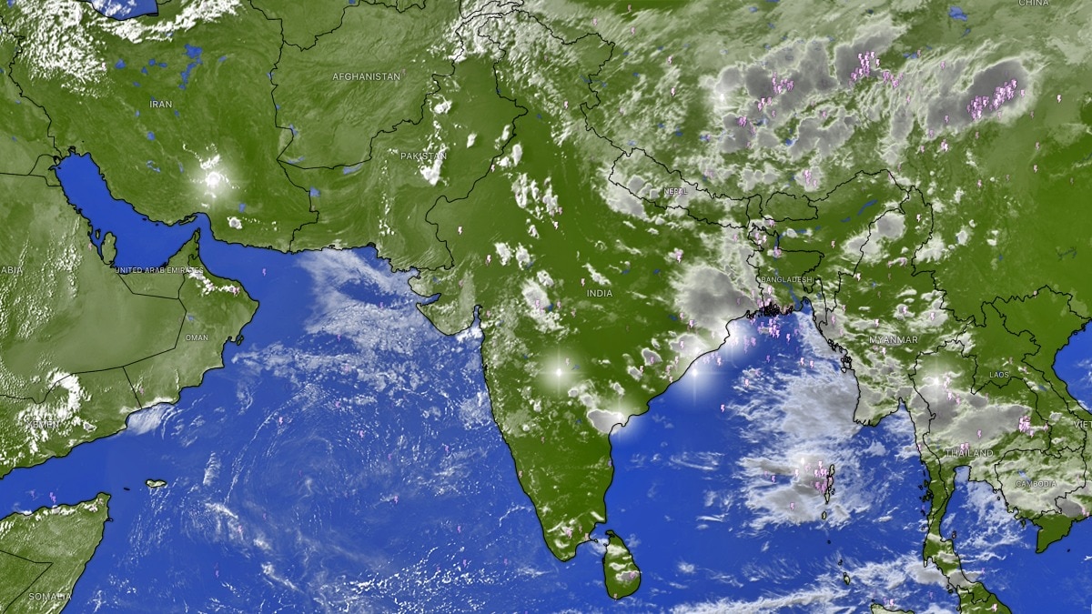
Recent satellite imagery shows a dramatic reduction in cloud cover across India, sparking questions about the onset of the monsoon's retreat. While skies appear clear, meteorologists clarify the official status.
- Satellite images show a significant drop in cloud cover over Northwest and Central India.
- The clearing of skies is linked to broader atmospheric changes and El Niño influence.
- Official monsoon withdrawal is not yet confirmed and is expected after September 15.
Fresh satellite imagery has captured a striking sight: vast stretches of the Indian subcontinent appearing almost cloud-free. This visual shift, particularly over the northwest and central regions, has raised urgent questions among meteorologists regarding whether the southwest monsoon has officially begun its annual retreat.
The phenomenon of reduced cloudiness is not localized to India alone. A substantial decrease in cloud cover has been observed across a massive corridor stretching from the Arabian Sea to the western Pacific, encompassing parts of China, Indonesia, and Sumatra. This large-scale atmospheric shift is being attributed to the complex circulation patterns influenced by El Niño, which are altering weather dynamics across South and East Asia.
Why This Matters
BozokMedia analysis shows that these visual changes in satellite data are critical indicators of shifting atmospheric pressure systems. The transition from a monsoon-driven climate to a post-monsoon phase dictates agricultural planning, water reservoir management, and regional humidity levels.
The visual absence of clouds from space is a powerful indicator of weakening monsoon activity, but it does not equate to the formal meteorological withdrawal.
Despite the dramatic imagery, experts caution that the monsoon has not officially withdrawn. The formal withdrawal process typically commences after September 15, starting from the northwestern parts of the country. The clear skies visible from orbit are currently viewed as a sign of weakening activity rather than a completed retreat.
Advanced weather models, including those from the European Centre for Medium-Range Weather Forecasts (ECMWF) and the Global Forecast System (GFS), suggest that conditions are becoming increasingly favorable for a retreat. A monsoon withdrawal anticyclone is expected to strengthen over northwest India during the latter half of September.
Meteorologists predict this anticyclonic circulation could reach maturity around September 21, potentially facilitating an organized and steady withdrawal of the southwest monsoon. As this phase progresses, the region can expect lower humidity, clearer skies, and a gradual shift toward drier conditions.
Frequently Asked Questions
Question 1: Does a cloud-free satellite view mean the monsoon is over?
Answer: Not necessarily. It indicates weakening monsoon activity, but the official withdrawal process follows specific meteorological criteria and usually starts after mid-September.
Question 2: What role does El Niño play in this?
Answer: El Niño influences global atmospheric circulation, which can lead to reduced rainfall and cloud cover across the Indian subcontinent and parts of Asia.