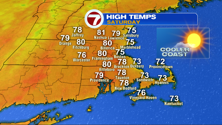
A passing cold front is set to sweep through Southern New England, replacing humidity with crisp, dry air for a stunning end to August.
- A cold front will significantly reduce humidity levels.
- Saturday and Sunday will feature mostly sunny skies and comfortable temperatures.
- The transition brings drier, cooler air perfect for outdoor activities.
Southern New England has been experiencing warm and somewhat sticky conditions lately. However, meteorologists are tracking a cold front moving through the region that promises to transform the local atmosphere. While some isolated showers and storms may occur this afternoon and evening, these are expected to be short-lived and will pave the way for a much more pleasant period.
Detailed Weekend Outlook
As the front moves through, cooler and drier air will settle in, creating what experts are calling a "stunner of a weekend." Saturday morning is expected to be mostly sunny with temperatures in the upper 50s. By the afternoon, inland cities will see highs in the upper 70s to low 80s, while coastal areas will remain in the mid-to-upper 70s. The most notable change will be the significant drop in humidity, leading to a crisp and comfortable environment.
Sunday follows a similar pattern, starting with sunny skies and temperatures in the upper 50s. The afternoon will see a slight temperature boost, with most cities reaching the low-to-mid 80s. While it will feel slightly more like mid-summer due to the warmth, the air will remain dry and breezy. However, keep an eye on the sky in the second half of the day, as clouds may increase and a stray shower could occur near sunset as another front approaches.
Why This Matters
BozokMedia analysis shows that this weather pattern is crucial for the region's transition out of the peak summer humidity. This window of dry, pleasant weather provides a vital opportunity for outdoor recreation and seasonal activities before the more unsettled pattern arrives next week.
The arrival of this cold front marks a significant shift toward more comfortable autumnal-style air masses.
For those attending the FM Championship at TPC Boston in Norton, the weather looks exceptional. Whether you are hitting the links or heading to the beach, the conditions are ideal—just remember to apply sunscreen to protect against the bright sun.
Historical Background
In the New England region, the transition from August to September is often characterized by these frontal passages. These shifts are essential in regulating the regional climate, moving from the stagnant heat of mid-summer to the more dynamic weather patterns of autumn.
Frequently Asked Questions
Question 1: Will it rain during the weekend?
Answer: Rain chances are low on Saturday, but a stray shower is possible around sunset on Sunday.
Question 2: When will the weather become unsettled again?
Answer: While Monday looks pleasant, the pattern is expected to become more unsettled with shower chances from Tuesday through Thursday.