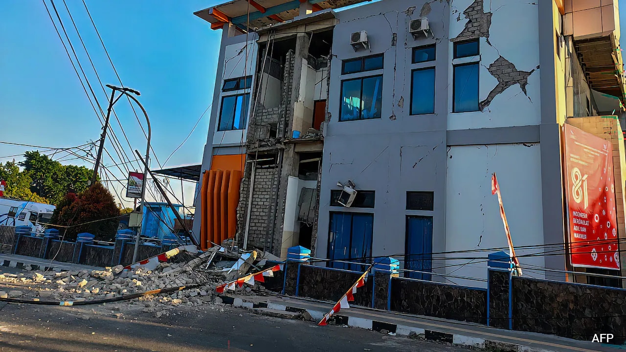
A powerful 7.7-magnitude earthquake has struck off the coast of Flores, Indonesia, causing structural damage and triggering widespread tsunami warnings across several provinces.
Key Takeaways
- A devastating 7.7-magnitude earthquake struck the Flores region.
- Tsunami warnings issued for East/West Nusa Tenggara and Sulawesi.
- Significant damage reported to homes and public infrastructure.
- Authorities have advised immediate evacuation to higher ground.
A massive 7.7-magnitude earthquake struck off the coast of Indonesia's Flores region early Saturday morning, sending shockwaves through the archipelago and triggering immediate tsunami warnings. The US Geological Survey (USGS) reported that the quake occurred at a depth of 10 km, with its epicenter located approximately 68 km north-northwest of Ende in the East Nusa Tenggara province.
Following the initial tremor, the Indonesian Meteorology, Climatology and Geophysics Agency issued urgent warnings for several provinces, including East Nusa Tenggara, West Nusa Tenggara, South Sulawesi, and Southeast Sulawesi. Residents in these coastal areas were instructed to abandon beaches and riverbanks immediately and move to higher elevations as officials monitored tide gauges for any signs of incoming waves.
Why This Matters
BozokMedia analysis shows that this seismic event highlights the extreme vulnerability of the Indonesian archipelago. Situated on the 'Ring of Fire', the region is constantly subject to intense tectonic activity. The immediate threat of a tsunami, combined with powerful aftershocks, creates a high-risk environment for coastal communities that are still recovering from historical seismic disasters.
The rapid deployment of tsunami warnings and the movement of coastal populations to higher ground are critical lifelines in minimizing casualties during such high-magnitude events.
Eyewitness reports indicate significant structural damage. In the Sikka regency, residents reported seeing buildings collapse, including the waiting room at the Pelni port terminal in Maumere. While there have been no immediate reports of casualties, the psychological impact and the physical damage to public facilities remain a major concern for local authorities.
Historical Background
Indonesia is an archipelago comprising over 17,000 islands, making it one of the most seismically active places on Earth. The region holds a traumatic memory of December 1992, when a magnitude 7 earthquake and subsequent tsunami near Flores claimed the lives of approximately 2,500 people.
Frequently Asked Questions
Question 1: Which areas are under tsunami warning?
Answer: Warnings have been issued for parts of East Nusa Tenggara, West Nusa Tenggara, South Sulawesi, and Southeast Sulawesi.
Question 2: Was there any immediate loss of life reported?
Answer: As of the latest updates, there are no immediate reports of casualties, though damage to property is significant.