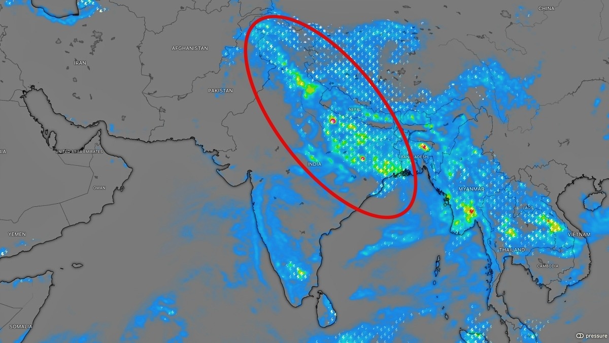
A significant interaction between a Western Disturbance and the monsoon axis is set to bring heavy rainfall to North India, potentially aiding rain-deficit states like Punjab and Haryana.
- Interaction between Western Disturbance and monsoon axis expected between Sept 4-7.
- Heavy to extremely heavy rainfall predicted for Himalayan states.
- Crucial relief expected for Punjab and Haryana amid monsoon deficits.
The month of September has commenced with distinct signs of shifting meteorological patterns across Northern India. A potent Western Disturbance is poised to emerge as a primary driver of monsoon activity in the coming days, potentially intensifying rainfall across both the Himalayan foothills and the vast northern plains.
Meteorological Outlook
Meteorological experts predict that the first major interaction between a Western Disturbance and the active monsoon axis, coupled with a low-pressure area, will unfold between September 4 and September 7. This atmospheric convergence is expected to trigger widespread and potentially intense precipitation across high-altitude regions, including Jammu and Kashmir, Himachal Pradesh, and Uttarakhand. These states could witness very heavy to extremely heavy rainfall as the system intensifies between September 4 and 6.
In the plains, the monsoon's revival will be evident starting September 3 and 4. Initially, scattered moderate to heavy showers are expected in Western Uttar Pradesh, Delhi-NCR, Eastern Haryana, Chandigarh, and Eastern Punjab. While the initial phase may be patchy, the interaction with the low-level monsoon trough will significantly expand the coverage and intensity of the rain.
Why This Matters
BozokMedia analysis shows that this weather event is critical for regional water security and agriculture. Currently, the monsoon has been significantly deficient in several key northwest states. Punjab is reporting rainfall approximately 33% below normal, while Haryana faces a deficit of about 22%. A widespread spell of rain during the first week of September could provide the much-needed recovery these states require to offset seasonal shortfalls.
The convergence of a Western Disturbance with the monsoon trough is a high-impact event that can redefine seasonal rainfall totals in a matter of days.
On a national scale, the monsoon remains uneven. As of September 1, pan-India rainfall was 13.6% below normal. While the southern peninsula and parts of Northeast India (including Assam and Meghalaya) continue to struggle with deficits, the immediate focus shifts to the North, where the upcoming system could set a renewed tone for the season's end.
Historical Background
Historically, the arrival of Western Disturbances in late monsoon periods often serves as a transitional mechanism. These mid-latitude cyclones, originating from the Mediterranean region, interact with tropical moisture to create intense weather systems that are vital for recharging groundwater and supporting late-season crop cycles in North India.
Frequently Asked Questions
1. Which regions are at highest risk of heavy rainfall?
The Himalayan states of Jammu & Kashmir, Himachal Pradesh, and Uttarakhand are expected to receive the most intense rainfall.
2. How will this affect Punjab and Haryana?
The rainfall is expected to help mitigate the current monsoon deficit, which stands at 33% in Punjab and 22% in Haryana.