A strengthening El Niño is set to push temperatures above average across much of the United States this September, though the Pacific Northwest may find relief with cooler patterns.
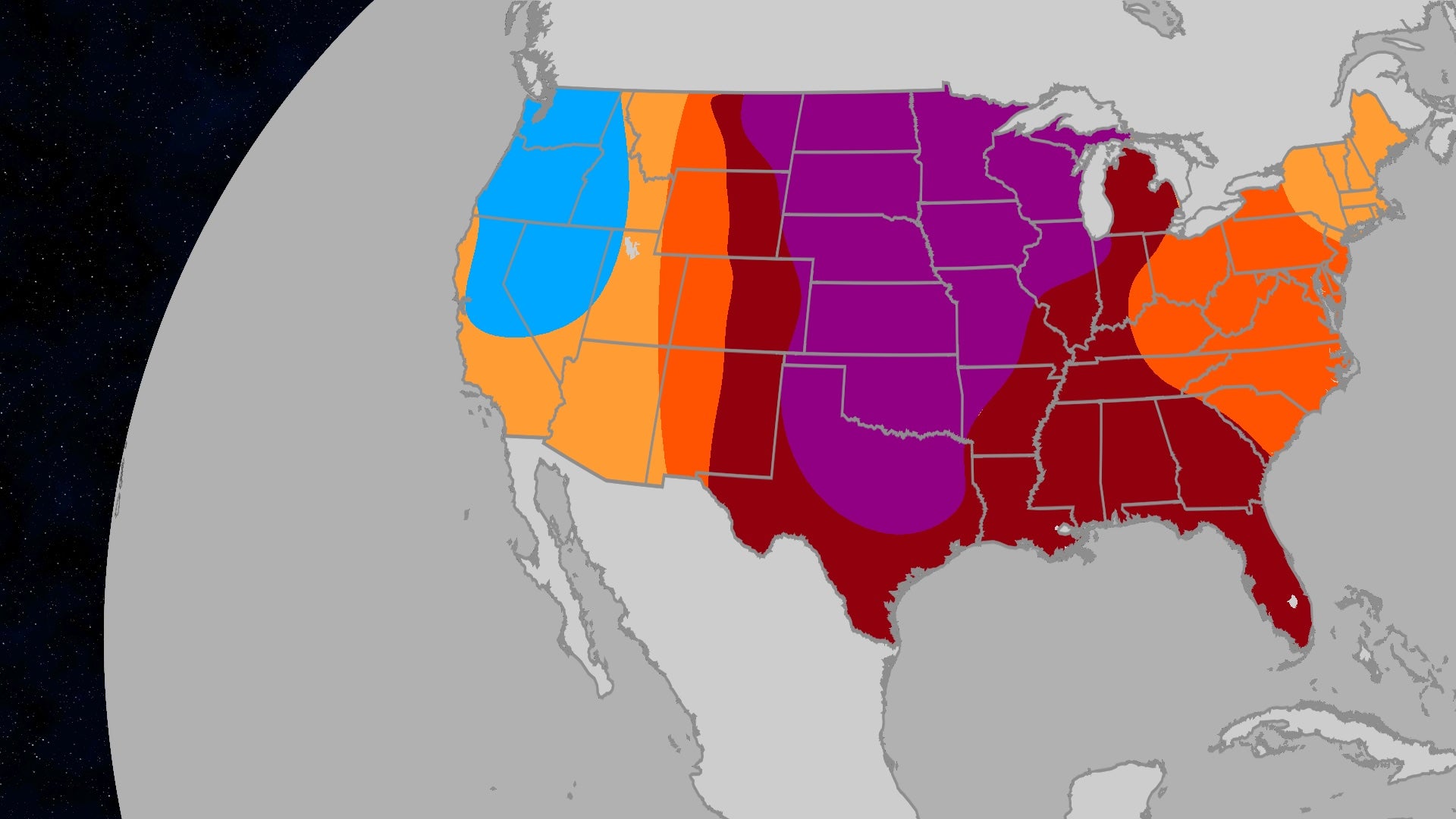
- Above-average heat favored from North Dakota through the Plains to Texas.
- Pacific Northwest expected to be the only region with below-normal temperatures.
- Current El Niño is developing faster than the historic 1997 and 2015 events.
- Heavy precipitation expected in the Four Corners region due to active monsoon.
As the first month of meteorological fall arrives, the United States is bracing for a September that defies traditional seasonal norms. According to a joint outlook released by Atmospheric G2 and The Weather Company, a vast majority of the country is expected to experience temperatures that exceed historical averages.
The most intense heat signal is concentrated in a central corridor stretching from North Dakota, through the Great Plains, and down into Texas. This trend of above-average warmth extends further to encompass the Rockies, the Gulf Coast, the Great Lakes, and the mid-Atlantic regions. While the Southwest and Northeast will also trend warmer, the deviation from the norm in these areas is expected to be modest.
Why This Matters
BozokMedia analysis shows that this shifting weather pattern is a direct consequence of rapid atmospheric warming. When the 'first month of fall' behaves like summer, it disrupts agricultural cycles and increases the strain on power grids, signaling a more volatile climate era.
"The current El Niño event is clearly outpacing all other events at this point in their development, including the 1997 and 2015 El Niños." - Todd Crawford, VP of Meteorology at Atmospheric G2.
Regarding precipitation, the 'Four Corners' region is poised to be the wettest area, as the North American monsoon remains active through late September. Increased rainfall is also projected for the interior West and the Plains, extending from the northern Rockies through the Midwest.
Conversely, the Pacific Northwest presents a paradox: while temperatures will be cooler—offering some respite to regions plagued by wildfires—the region is expected to remain dry. This lack of moisture tempers the benefits that cooler weather typically brings to fire-weary landscapes. Meanwhile, the East and Southeast, including Florida and upstate New York, are trending toward drier-than-normal conditions.
| Region | Temperature Trend | Precipitation Trend |
|---|---|---|
| Central US (Plains/Texas) | Above Average | Above Average |
| Pacific Northwest | Below Average | Drier |
| Southwest (Four Corners) | Above Average | Wetter |
| East/Southeast | Slightly Above | Drier |
Frequently Asked Questions
1. Why is the Pacific Northwest cooler than the rest of the US?
Regional atmospheric patterns are bucking the national trend, providing a cooling effect that offers relief from recent fire weather.
2. How does this El Niño compare to previous ones?
According to experts, this event is intensifying more rapidly than the record-breaking El Niños of 1997 and 2015.