Depressions forming over the Bay of Bengal deliver a large share of India's monsoon rainfall. This article explains why they develop so frequently and what impact this week’s deep depression will have.
Key Takeaways
- The Bay of Bengal spawns the majority of India’s monsoon depressions.
- Depressions are responsible for a large portion of seasonal rainfall across the subcontinent.
- This week’s deep depression is set to bring heavy rain to multiple northern and central states.
What Is a Depression?
A depression is a low‑pressure atmospheric system that behaves like a giant vacuum, drawing air inward. Earth’s rotation makes the inflowing air spiral, causing warm, moisture‑laden air to rise, cool, and condense into towering rain clouds. According to the India Meteorological Department (IMD), sustained winds of 31‑49 km/h define a depression, while 50‑61 km/h winds upgrade it to a deep depression.
Why Does the Bay of Bengal Produce So Many Depressions?
During summer, sea surface temperatures in the Bay often exceed 28 °C, evaporating huge volumes of water. Simultaneously, intense heating over north‑western India creates a vast low‑pressure area on land, pulling moist oceanic air inland. When sea temperatures stay high, humidity extends high, vertical wind shear remains weak, and Coriolis force supplies enough spin, these disturbances organize into depressions. Roughly three‑quarters of India’s monsoon depressions originate here.
Why Depressions Matter
Besides causing floods, depressions transport massive moisture inland, delivering rain far from the coast. Their tracks commonly stretch from Odisha and West Bengal through Chhattisgarh, Madhya Pradesh, Uttar Pradesh, and sometimes reach Rajasthan and Gujarat. Without them, central and northern India would receive markedly less rainfall.
What Makes This Week’s System Special?
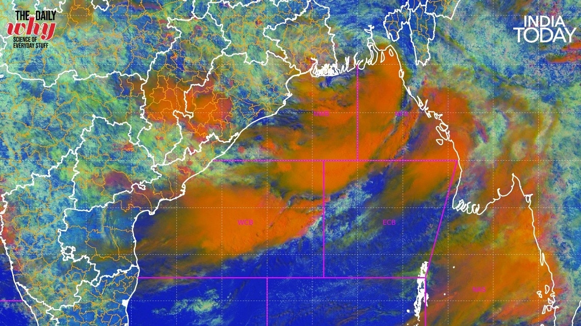
The current system intensified into a deep depression over the north‑western Bay before crossing the Odisha‑West Bengal coast. INSAT‑3D satellite images show a cloud shield nearly 1,000 km long, expected to move inland in the coming days. Its timing aligns with the monsoon trough—a belt of low pressure across northern India—creating twin engines that pump moisture across the subcontinent and trigger widespread heavy to very heavy rain in states from Odisha to Delhi, Uttarakhand, and Himachal Pradesh.
The Bigger Picture
India typically experiences four to six depressions each monsoon season, accounting for a substantial share of total seasonal rainfall. While a deep depression sounds ominous, it remains one of nature’s most efficient ways to distribute life‑giving rain across the country.
Historical Background
Over the past decades, Bay of Bengal depressions have alternately delivered record‑breaking floods and vital water supplies. The 1970s saw exceptional rains that boosted agricultural output, whereas the 1999 event caused massive displacement. Lessons from these extremes have driven improvements in forecasting and early‑warning systems.
Why This Matters
BozokMedia analysis shows that understanding the mechanics of Bay of Bengal depressions is crucial for improving seasonal rainfall forecasts, which directly affect crop planning and disaster preparedness across the subcontinent.
"Depressions act as the primary conveyor belt of moisture for India's interior," says Dr. Anil Kumar, senior climatologist at IMD.
Frequently Asked Questions
How is a monsoon depression defined? It is a low‑pressure system with sustained winds of 31‑49 km/h that generates widespread rainfall.
What distinguishes a deep depression from a regular depression? A deep depression has stronger winds (50‑61 km/h) and typically produces more extensive and intense precipitation.