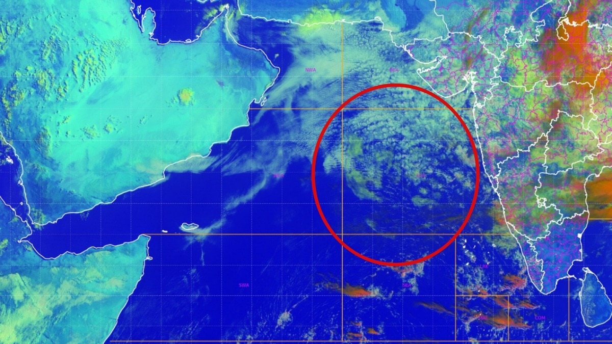
Satellite data shows unprecedented inactivity in the Arabian Sea, leading to a significant rainfall deficit across much of India.
- Limited cloud activity in the Arabian Sea is choking monsoon moisture.
- National rainfall has remained 13% below normal since June 4.
- Monsoon withdrawal is expected between September 10 and September 18.
Recent satellite observations from INSAT-3DS and global weather monitoring networks have captured a concerning development in the Arabian Sea. The sea, which serves as a vital moisture reservoir for India's southwest monsoon, is exhibiting an unusually quiet state with minimal cloud formation. This lack of activity is directly impacting the monsoon's strength across the subcontinent.
According to meteorological data, India's nationwide rainfall has been lagging at 13% below normal since the beginning of June. A persistent ridge over northwest India is further suppressing widespread precipitation in the western and northwestern regions, effectively restricting the monsoon's reach. While some relief is being felt in eastern parts of the country due to low-pressure systems from the Bay of Bengal, the overall distribution remains highly uneven.
Why This Matters
BozokMedia analysis shows that the suppression of moisture from the Arabian Sea creates a critical imbalance in the Indian hydrological cycle. This deficit poses a substantial risk to the agricultural sector, as the monsoon enters its final, crucial phase. Without the intervention of fresh low-pressure systems from the Bay of Bengal, the rainfall deficit could lead to prolonged dry spells in key farming belts.
The unusual stillness of the Arabian Sea acts as a bottleneck for the entire monsoon mechanism, limiting the moisture available for continental rainfall.
Current weather models indicate that while eastern Madhya Pradesh and Chhattisgarh may experience heavy showers, large swathes of Rajasthan, Gujarat, Haryana, Delhi-NCR, and western Uttar Pradesh are likely to remain dry. The India Meteorological Department (IMD) has noted that although rainfall is subdued, there is no indication of an early monsoon withdrawal.
Meteorologists suggest that the monsoon withdrawal process is expected to commence between September 10 and September 18, aligning with historical climatological patterns. This implies that while the intensity of rain may be low, the monsoon circulation will likely persist through the first half of September.
Frequently Asked Questions
Question 1: Is the monsoon withdrawing early?
Answer: No, current assessments suggest the monsoon will stay active until mid-September, with withdrawal expected between Sept 10-18.
Question 2: Which regions are facing the most drought-like conditions?
Answer: Northwestern India, including Rajasthan, Gujarat, and Delhi-NCR, is seeing significantly lower rainfall due to the current weather ridge.