India's monsoon is now largely confined to the heartland, with eastern Madhya Pradesh receiving steady showers while much of the country faces patchy clouds or clear skies. The growing influence of El Niño is creating an uneven rainfall pattern across the subcontinent.
- Monsoon activity is now concentrated in central India.
- El Niño is weakening the overall rainfall distribution.
- Low‑pressure systems still generate localized rain.
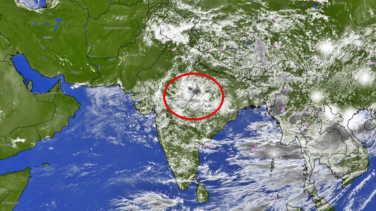
New Delhi (Aug 20, 2026) – India’s monsoon appears to be surviving largely on the strength of its central heartland, with widespread rainfall continuing over parts of east Madhya Pradesh while much of the rest of the country remains under scattered clouds or mostly clear skies.
Latest satellite imagery paints a striking picture of an uneven monsoon. Dense cloud clusters associated with active weather systems are concentrated over central and eastern parts of the country, while large stretches of western, northern and southern India show relatively limited cloud development.
East Madhya Pradesh has emerged as a key region keeping the monsoon circulation active. Persistent rain, low‑pressure systems and other monsoon disturbances are pumping moisture into central India, sustaining rainfall in this area.
Elsewhere, the scene is far less impressive. Large parts of the nation are witnessing either patchy cloud cover or mostly clear skies, indicating a lack of widespread monsoon activity. These dry conditions are especially evident in regions that normally receive sustained rains.
Intense thunderstorms were also observed over Jammu & Kashmir and parts of north Punjab. While these storms brought localized spells of heavy weather, they did little to alter the broader picture of a monsoon struggling to maintain widespread activity.
The weakening pattern comes as El Niño increasingly asserts its influence over the Indian monsoon. El Niño, involving abnormal warming of the central and eastern tropical Pacific Ocean, can disrupt atmospheric circulation globally and is often linked to a weaker southwest monsoon and uneven rainfall distribution for India.
Nevertheless, depressions and low‑pressure systems continue to form and move across the region, providing a line of defence against El Niño’s suppressing effect. These systems act as temporary rain engines, pulling in moisture and triggering widespread rainfall as they move inland, though the overall rainfall has remained slightly below normal.
Why This Matters
BozokMedia analysis shows that prolonged central‑India rainfall, while peripheral regions stay dry, could strain agricultural output in key grain‑producing states, potentially impacting food‑grain prices nationwide.
"El Niño’s influence is intensifying, yet central India’s monsoon dynamics are still providing a crucial buffer," says climate expert Dr. Ajay Singh.
Frequently Asked Questions
Q1: Will El Niño cause a sudden increase in rainfall across the whole country in the coming weeks?
A: Unlikely; current data suggests rainfall will remain uneven, with most of the country staying dry outside the central belt.
Q2: What steps should farmers take in response to this pattern?
A: Implementing water‑conservation measures, adopting drip irrigation and planting drought‑resilient crops are essential strategies.