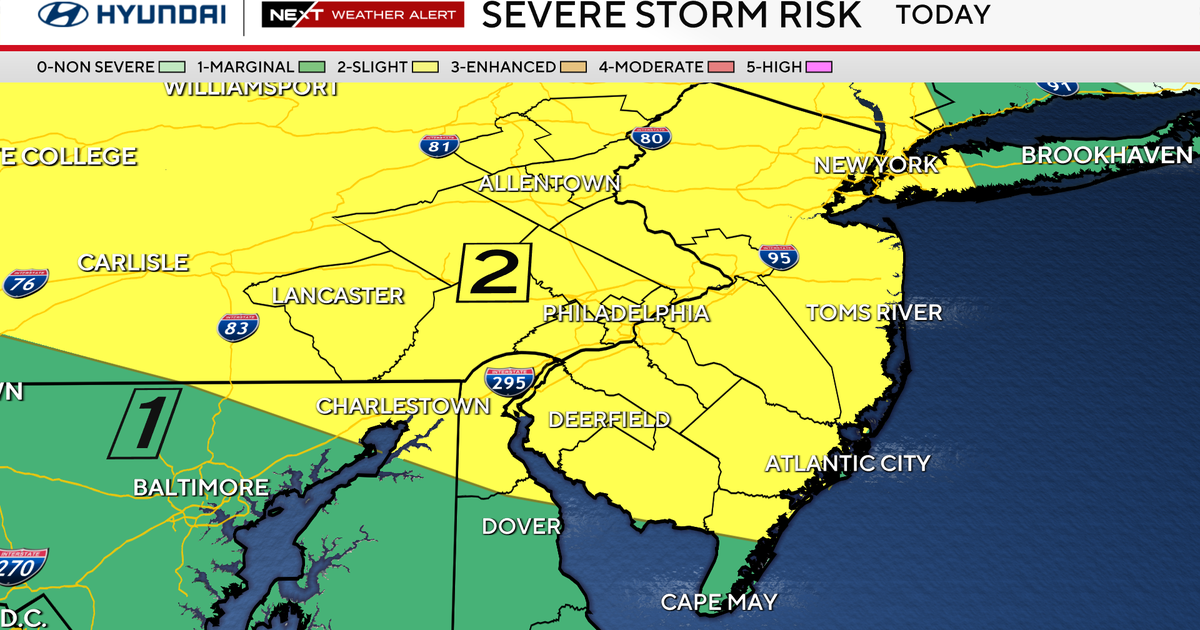
A tornado warning for Burlington County, NJ, has been lifted, but the Philadelphia region remains under threat of severe thunderstorms, heavy rain, and damaging winds.
- Tornado warning in Burlington County, NJ, has been officially canceled.
- Severe thunderstorm warnings remain active for parts of the Delaware Valley.
- Heavy rain, hail, and gusty winds are expected through Thursday.
- A weather break is anticipated by Friday, leading to a pleasant weekend.
The tornado warning previously issued for Burlington County, New Jersey, was canceled on Tuesday night as severe storm systems moved through the Philadelphia region. While the immediate tornado threat has subsided, the area remains on high alert due to ongoing severe weather activity.
Meteorologists indicate that while the severe thunderstorm watch has expired, specific warnings are still in effect for various parts of the Delaware Valley. These storms are characterized by heavy rainfall, damaging winds, frequent lightning, and the potential for hail. Residents are advised that despite the cancellation of the tornado warning, isolated tornadoes cannot be entirely ruled out during these intense cells.
Why This Matters
BozokMedia analysis shows that the current atmospheric setup, characterized by a large ridge of high pressure to the south, is creating a volatile environment. This pattern forces storms to track from the northwest to the southeast, repeatedly triggering severe weather alerts during afternoon and evening hours.
The transition from extreme heat to sudden severe thunderstorms creates a high-risk environment for flash flooding and wind damage.
Looking ahead, the heat and storm threats are expected to persist through Wednesday and Thursday. A significant cold front is projected to move through the area by Thursday, which may begin to push the severe weather threat further south. However, the immediate concern remains the combination of high humidity and sudden convective activity.
Historical Context
The Mid-Atlantic region, including parts of New Jersey and Pennsylvania, frequently experiences these 'unsettled patterns' during the transition from summer to autumn. The interaction between lingering summer heat and incoming frontal systems often results in high-impact weather events.
7-Day Forecast Outlook
| Day | Weather Condition | High Temp (°F) |
|---|---|---|
| Wednesday | Severe Storm Alert | 84 |
| Thursday | Storms & Heat | 90 |
| Friday | Showers South | 87 |
| Saturday | Partly Cloudy | 82 |
| Sunday | Mostly Sunny | 79 |
Frequently Asked Questions
1. Is it safe to go outside in Philadelphia right now?
Answer: It is advised to stay indoors and monitor local weather updates, as severe thunderstorms with lightning and heavy rain are still possible.
2. When will the stormy weather end?
Answer: The unsettled pattern is expected to break down by Friday, offering a much calmer and cooler weekend.